
Cingkuak Island
A nearby island with maritime-history context. Boat access, routes, and visiting conditions should be confirmed locally.
Painan · Pesisir Selatan Regency · West Sumatra
A coastal bay that opens Painan toward its small offshore islands—best read slowly, rather than simply passed through.
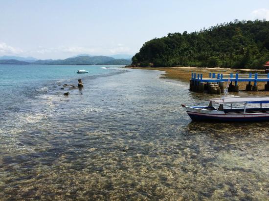
Pantai Carocok landscape documentation · source: TripAdvisor, served locally.
Orientation
Pantai Carocok sits on Painan’s western side, close to the town centre and facing a chain of small islands. Its value lies in the relationship between shoreline, calm water, the route toward Cingkuak Island, and Painan’s coastal landscape.
Coast and island
From the Pantai Carocok shore, Cingkuak Island is an easy landmark. Pesisir Selatan Regency publications place this small island roughly 200 metres west of the beach and note remnants associated with a Portuguese fort and grave.
A considered visit therefore goes beyond a photograph. Watch the light change across the bay, then notice how boats, jetties, and small islands connect Painan to its waterfront. Respect signs, barriers, and sea conditions in force when you arrive.
This is an independent, non-commercial guide. It distinguishes relatively stable location facts from field services that may change.
A nearby island with maritime-history context. Boat access, routes, and visiting conditions should be confirmed locally.
This is an exposed outdoor space. Bring sun or rain protection, drinking water, and follow staff notices before entering the water.
Use photo areas thoughtfully, do not climb structures, and leave space for residents and beach-service activity.
Visit plan
Hours, fees, facilities, and water activities can change with weather, holiday periods, maintenance, or management policy. Use this summary to prepare—not as a substitute for local confirmation.
Comfortable time
Suggested stay
Entry / costs
Map hours
Detailed transport
Tell drivers “Pantai Carocok, Painan”. The beach is close to central Painan; travel time from outside town depends greatly on weather, traffic, and road conditions.
Minangkabau Airport in the Padang area is the principal air gateway. Continue by hired vehicle, licensed taxi, or available transport toward Painan. Leave a buffer—it is not a short airport transfer.
Intercity connections along the Padang–Painan corridor can change. Check active departure points, schedules, and drop-offs on the travel day, then continue on foot or by local transport from central Painan.
Confirm a safe drop-off or pick-up point at the edge of the beach area and an estimated fare before departure. Availability can differ by hour and demand.
Follow signed directions and use designated parking. At weekends or holidays, arrive earlier and do not stop on road shoulders that interrupt traffic.
Facilities and needs
Availability at a coastal attraction can change. The list below highlights what to plan for, without promoting businesses or operators.
Look for facility signs on arrival and bring personal essentials as needed. Help keep sand and water clean.
Use management-designated areas. Capacity and fees may differ on public holidays or during events.
Around Painan, expect types of places such as simple food stalls, restaurants, drink shops, and daily-need stores. Carry water for a longer stay.
Painan has guesthouses, homestays, and hotels with varying levels of service. Choose by access and mobility needs.
Markets, minimarkets, and small shops are easier to find in central Painan than by relying on one beachside point.
Plan fuel before travelling along the coast. Check active petrol stations or EV charging points through reliable channels.
Beach and surrounds
Choose the category of place that suits your needs—simple food stall, restaurant, drink shop, or daily-needs store. Consider opening hours, hygiene, dietary needs, and travel distance; this guide offers no rankings or commercial recommendations.
Nearby places
A small island off Pantai Carocok associated with traces of Portuguese history. Confirm boats and access conditions before planning a crossing.
The town centre is close to the beach and useful for food, supplies, transport, and orientation before or after a visit.
The wider coast offers other views of the bay. Use official routes, check weather, and do not rely on unclear paths.
Location
The embedded map below is set to Indonesian. Routes, transport services, and local business details shown there can change independently of this guide.
Open in Google MapsQuestions
The beach may apply entry, parking, or separate charges for certain activities. As conditions can change, read notices and ask local staff before assuming a cost.
Morning or late afternoon is often more comfortable for heat and the bay atmosphere. Do not rely on time alone—check weather and sea conditions on the day.
For the beach and bayside area, 60–120 minutes is a reasonable frame. Add time if an island crossing or water activity is available.
Both are commonly sought in visitor areas, but capacity, access hours, cleanliness, and fees can change. Follow local signage and have an alternative in central Painan.
Safety depends on sea conditions, weather, safety equipment, and staff guidance that day. Do not enter water or board a boat when there is a warning or restriction.
No. Pantai Carocok Guide is an independent, non-profit visitor-information project; it does not represent government, site management, or any business.
Sources
Location and history context is summarised from Pesisir Selatan Regency Government publications. Map details—including displayed rating and hours—come from Google Maps and can change. Use official channels or local staff for important travel decisions.